![[Translate to English:] Wanderrouten](/fileadmin/_processed_/9/a/csm_Hotelfotos_DieENG_VeronikaAnnaFotografie_NEU-042_eb65cbda8b.jpg "[Translate to English:] Wanderrouten")
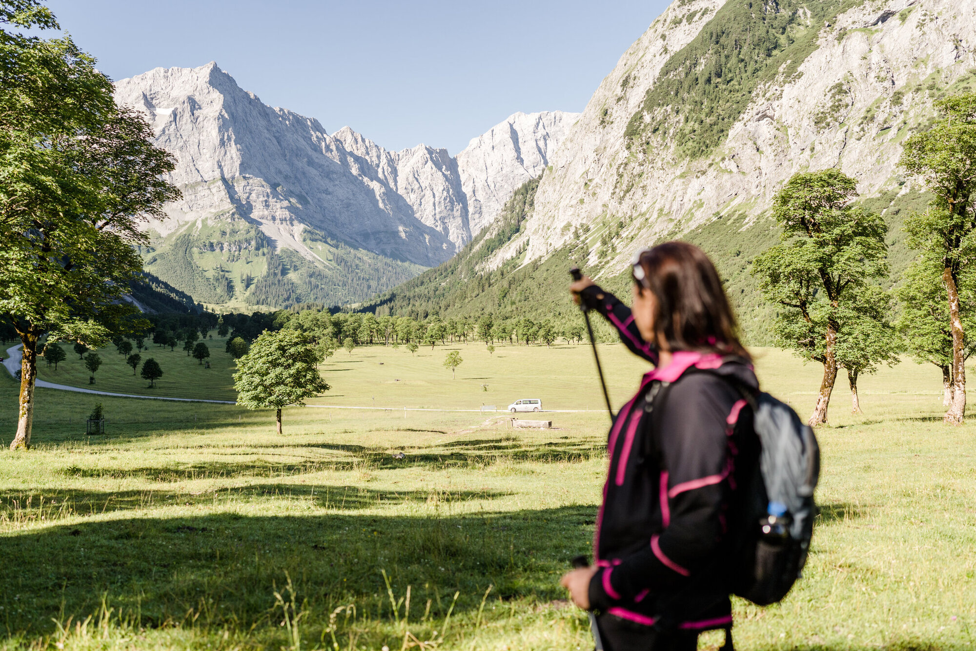
From the Eng you can do many hiking and mountain tours. The 700 m long footpath from a large parking lot to the Almdorf, surrounded by the beautiful nature and the ancient maple trees, is a car-free zone.
An easy hike, for which you do not need any alpine experience, is the way to the Enger Grund. No special equipment is necessary, but sturdy shoes and rain clothing are recommended. It takes about 2 hours for the entire route.
Hiking routes around the Alpine guesthouse & Naturhotel:
- Engergrund (Bergfex)
- Gamsjoch (Hoehenrausch.de)
- Falkenhütte (Bergfex)
- Gumpenspitze (Alpintouren.com)
- Plumsjoch (Bergfex)
- Binsalm (Bergfex)
- Sonnjoch (Zipfelkreuz.de)
- Mahnkopf 2-Tages-Tour:
First day: Hinterriß – Falken hut (Bergfex) | Second day: Falken hut – Mahnkopf – Eng (Outdooractive.com) - Interaktive Karte TVB silver region Karwendel
Further hiking destinations can be found on the website of Alpenpark Karwendel www.karwendel.org.
Here you can also download the hiking guide APK Band Nr.5 “Karwendel Touren 2″
Kirchlstein or Brotzeitfelsen 1600 m
From us - to the Engalm before slowly left of the Almöden along in the direction of Panoramaweg (power plant house on the left side) then stay on the right side and finally cross the stream.
Go right up the stream until you come to the visible path, then through alpine roses and mountain pines to Kirchl, a total of about 2,5 hours, 400 meters - the view from the Kirchlstein alone is already a dream....
Enger Grund - Talschluß
Comfortably through the Almdorf, then to the left, past benches; further to the Brückerl – t hrough the Enger Grundbach leads a narrow irregular trail to the Engergrund; on the left you will see a hidden romantic waterfall, on alpine meadows you can walk around in the background the gigantic Grubenkarwand 2660 m, which leaves a strong impression; back again the same way, about 2 – 2,5 hours in a very comfortable tempo...
Hiking to the Bins-Alm 1500 m » Binshochleger » Driaggen (4h)
A special tour, important is a stop in the Binsalm, as the host takes care of his guests and their mood. For the advanced hikers: it goes further
to the Binshochleger, -Panoramasteig, -Driaggen- magnificent view of the entire Eng valley and the largest Nature Park in Europe in Tyrol.
Karlalm 1.180 m
We take a hiking bus to the parking lot no.7, go the small bridge over (Rissbach). We take the comfortable forest path with several curves up to the Karlalm, in front of us spreads a small gentle green Kessel with the two pastures. If you go left to the Marterl you will have a fantastic view across to the Lalider valley with the impressive rock walls - about 2,5 hours, altitude is not relevant.
Rohn valley – Rohn valley pasture 1262 m
We take a bus to the Hinterriss 928 m, we park in the immediate vicinity of the information centre Karwendel (a rewarding-interesting visit + this is free) then we walk comfortably to the Rohn valley pasture, about 1,5 hours; who has not had enough, can go further to the Rappenspitze (Next point).
Rappenspitze (Rappenklammspitze) 1,835 m
Left over the almost dry stream bed past the hunting lodge towards Hochalpkopf 1,770 m or Rohnberg 1,771 m - these are gentle green Almbergkopf pastures with a great view.
or turn left instead of right up to the Rappenspitze, whereby the last few meters have to be a bit sure-footed - by the way, it is also called Rappenkammspitze!!!?
called!!!? Total walking time from Hinterriss approx. 3 hours, difference in altitude 910 m.
Falken hut 1848 m
Either directly over the Hohljoch 1974 m below the Lalidererwände along to the Falken hut, walking time approx. 3 hours - 758 meters – from easy to medium level of difficulty. Or across the Lalider valley, with a view of fantastic Lalidererwände 2,600 m; at Lalidersniederleger 1526 m - we go right towards the Ladizköpfl (for advanced hikers here would be the great possibility to go to the Mahnkopf 294 m - a wonderful view over the Karwendel- then relaxing walk to the Falken hut; way back as described above. We can take the hiking bus to the Laliderer valley (we save 2 hours) - otherwise total walking time with the Mahnkopf – 5,5 hours, about 850 meters, walking time about 3,5 hours.
Karwendelhaus 1.771 m
There are 2 possibilities: from the ENG 1216 m over the Hohljoch 1974 m below the Lalidererwänden along to the Falken hut, here you can also take to the left towards the klein Ahornboden 1399 m further up to the Hochalmsattel 1803 m to the Karwendelhaus, altitude of about 750 m. Walking time approx. 6 hours.
To the Karwendelhaus across the 12 km wide Johannes valley to the klein Ahornboden; the Hochalmsattel 1803 m to the Karwendelhaus. This is the longer version with a little less altitude, but walking time about 7 hours - if we do this as a guided hike, we take the hiking bus to the klein Ahornboden, then the tour is of course shorter.
Birkkarspitze 2.749 m
Highest mountain in the Karwendel, only for vertigo-free, sure-footed.
We take a hiking bus across the Johannes valley to the klein Ahornboden 1399 m; from there we hike to the Hochalmsattl 1803m to the Karwendelhaus; here we take left, it goes steeply uphill - soon comes the turnoff (easier tour to the Hochalmkreuz 2192 m) or straight towards the Schlauch-birkkar (Biwak hut) up to the top 2749 m; the last 100 meters is a wire rope safety attached; back down to the Biwak hut - here a fantastic back round trip is suggested, but really only for absolutely strong hikers, over the Östliche-Mittlere- Westliche Ödkarspitzen 2745 m, over the Brendelsteig back to the Karwendelhaus 1350 meters – a full-day tour!
Gamsjoch 2.452 m
From the opposite side of the alpine guesthouse Eng we go up the long steep Rinne, then we go past three natural springs and come to the Gumpenjöchl 1974 m; then we go right on the marked natural climb up to the Gamsjoch 1236 meters, walking time about 3,5 hours. Many, many chamois, single ibexes, marmots from mid-July to late August. Edelweis blossoms, absolute enjoyable tour, view up to the Rofan, Ziller valley, Zugspitze massif, etc. ... On the way back we go over the Gumpenjöchl, Lalidersalm Hochleger to the Hohljoch 1974 m and then over the Enger Grund to the alpine guesthouse ENG - a day trip, feeling for the nature and a lot of energy should be brought along... A total of about 6 hours walking time
Faule E N G
Quaint, romantic, rustic, moderate, mysterious hiking tour from the Gross Ahornboden 1120 m between the Gramaikar and the Bärenwandkopf, go to the right through the forest, over the old Mauleselsteig up to the faule Eng; between the Sonnjochanstieg and the Gramaijoch 2017 m many green pastures with small ponds, marmots and chamois - here we can go either right down to the Gramai Hochleger 1756 m or up to the Gramaijoch 2017 then continue to the Steinblümelkopf 2010 m, a beautiful Grasberg with a view of the Gross Ahornboden and much more; then to the Beinsattel 1993 m, down to the Binshochleger, Binsalm 1503 m up to the ENG, here the altitude is not the decisive factor, after all, about 900 meters, but the nature itself, the variety of stone, forest, meadow, small lakes and much more - a day trip!
Lamsenjochhütte 1.953 m
Via the Panormaweg, Drijaggenalm above the Binshochleger over the three wild grassy hills to the Lack, then in the direction of the Lamsenkar to the west side of the Lamsenjoch 1940 m; then hike right up to the Lamsenjoch hut, where we will make a stop. The way back goes up to the Lamsenjoch via the Hahnkampl 2080 m (over 8 m sure-footed is required) then back to the Bins-Gramaisattel 1903 m, down to the Binshochleger 1645 m to the Binsalm 1502 m. Challenging – a day trip, altitude 764 m.
Lamsenspitze 2.508 m
Only for sure-footed and vertigo-free.
From the Alpine guesthouse ENG after the bridge we turn left to the Binsalm, then to the Binshochleger, Lamsenjoch - as above - to the Lamsenjoch hut, from there turn right at the junction and then left towards the Brudertunnel - newly insured path through the tunnel to the Lamsscharte up to the Lamsenspitze. Altitude 1292 m. Return via the Lamsenscharte to the Lamsenjoch hut and then back to the ENG.
Lamsenjochhütte 1953m » Schafjöchl 2.157 m
Same tour to the Lamsenjoch hut, from the hut, then left up to the Schafjöchl, this is a nice tour, you have a nice view, altitude 941m - walking time about 3,5 hours
Sonnjoch 2.457 m
The most beautiful round trip, we take the hiking bus to the Pertisau, towards the Gramai, before the last Weiderost we go right over the Bärenlahner to the Bärenlahnersattel 1994 m - a great view of the Gross Ahornboden and the Karwendel mountains, here you can see an ibex; after a short rest we go left up to the Sonnjoch; a moderate varied tour, endurance is an advantage; then we go down towards the Gramai Hochleger 1756 m, either over the Binnsattel - Binsalm in the ENG or even for someone who would like more we can go down through the "FAULE ENG", altitude 1245 meters , a demanding day trip, after which you have a lot of impressions.
Plumshochhütte 1.630 m
We take a hiking bus to the Hagel hut 1077 m, then we continue our tour over the Rißtalbach bridge, after about 500m we go right over the Steigerl up in the direction of the Plumsalm, 1423m (Niederleger); here we turn to the left from the path (to the right is a biking trail) to the Plumsjoch hut - walking time about 2 hours. We have several options:
Mondscheinspitze 2.106 m
From the Plumsjoch hut up to the Plumsjoch 1821 m, then down to the Mondschein valley and then steeply up to the top of the Plumsjoch hut. Walking time about 1,5 hours, 476 meters. This tour is for experienced, fit and sure-footed climbers; we take a hiking bus to the Pertisau - to the Gern valley, after the Pletzachalm steeply uphill to the Schleimsattel; then to the left towards the Kelberg up to the Mondscheinspitze; there are 922 meters to overcome - but if you would like to have a round trip, then we can hike via the Plumsjoch in the Eng. This is a day tour.
Kompar 2.011 m
From the Hagel hut (parking space 8) 1077 m over the bridge to the Hasental Alm – low, average - 1563 m (here you have a fantastic view of the Gross Ahornboden) Hochleger - open your eyes, because here you can see many marmots - then we go to the junction - Satteljoch, then we go left, up to the Kompar, 934 meters - then back to the junction Satteljoch, here we can hike right over the Grasbergkamm along up to the Plumssattel - down to the Plumsjoch + continue the trail - Plumsalm - then the forest path up to the junction to the Hagel hut, after that we come down the narrow path to the Hagel hut - duration about 6 hours - altitude 934 m, a beautiful day trip.
Grasberg Joch 2.020 m » Hölzstaljoch 2.012 m » Fleischbank 2.026 m
Starting point via the Karlalm 1180 m to the Grasbergalm 1540 m, we take left, past the Grasbergsattel (we will probably meet marmots here) up to the Grasberg, here we can hike below the Grasberg up to the Hölzelstaljoch, 2012 m, here is one of the 3 peaks - enjoy the views; then we go down to the Fleischbank (be careful here), from here it goes downhill steeply up to the Steilegg Jagd hut; now it will not be long before we reach the royal hunting lodge, which is at the altitude of 950 m. This is a long day trip; perfect in the spring - when everything is blooming or in the autumn when you can have great visibility conditions; just a dream.
Torscharte 1.815 m » Torkopf 2.014 m
Wir fahren mit unserem Wanderbus bis Hinterriss, beim Infozentrum vorbei parken wir am Rohntalparkplatz, 928 m, dann gehen wir Richtung ENG, wandern ins Tortal hinein – bei der Tortalalm vorbei hinauf bis zum Hochleger, Murmeltiereldorado, auch Schlangen gibt es hier, bis zur Torscharte, wem die Tour noch nicht genug angestrengt hat kann rechts weiter hinauf zum Torkopf wandern, von Mitte Juli bis Mitte August findet man Edelweiß, auf alle Fälle lohnende Ausblicke, wieder hinunter zur Scharte und auf der anderen Seite runter ins Rohntal, zuerst zur Rohntalalm 1.262 m nach kurzer Rast das Rohntal hinaus zum Parkplatz, schöne ab er leicht kondtionsstarke-ausdaurende Tagestour, Höhenunterschied Scharte 887 m; Torkopf 1.086 m.
Torscharte 1.815 m » Torkopf 2.014 m
We take our hiking bus to the Hinterriss, we park at the information centre, at the Rohntalparkplatz, 928 m, then we go towards the ENG, further to the Tortal – we pass the Tortal pasture, going up to the Hochleger, to the Torscharte; here live marmots, snakes live here too. If the tour has not been challenging enough for you, you can continue going right up to the Torkopf. From middle of July to middle of August you will enjoy Edelweiss, in any case you will have rewarding views; on the way back we go down to the Scharte and on the other side down to the Rohntal, first to the Rohntalalm 1262 m, after a short rest, we go to the parking lot. A nice day tour, from an easy to challenging level. Altitude Scharte 887 m; Torkopf 1086 m.
Vorderskopf 1.858 m
A beautiful mountain view.
We go by bus to the Hinterriss, in the direction of Vorderbachau / Vereinsalm, if possible a bus drives the forest road past the hunting lodge up to the Sattel; then the hiking tour starts, it is about 1,5 hours - ideal as a sunrise or sunset tour, the summit is bigger than 3 football fields, with a clear view you can see the TV tower in Munich.
Tölzer Hütte 1.835 m
We go by a hiking bus to the Oswald hut, from there we go either on foot or Thomas - host of the Oswald hut, brings us up the Mosenweg; from the Mosenalm we go about 1500 m keeping to the right below the Schafreiters over to the Tölzer hut, then we hike back down to the Leckbach. A nice day round trip, altitude 932 m.
Schafreiter 2.101 m
A tour as described above, but from the Mosenalm from the junction we go uphill keeping to the left in the direction of Schafreiter; from here it goes through the pines – up to the summit; the descent requires some surefootedness at the beginning, also before we reach the Tölzer hut, it is rough and stony - but the hut in front of you is right there; the descent from the Tölzer hut is like described above, altitude 1199 m - a demanding full-day tour.
Grasköpfl 1.726 m » Grammsberg 1.741 m
Ungefähr 500 m nach der Oswaldhütte, 847 m (Richtung Vorderriss) geht man rechts einen wunderschönen alten Reitsteig langsam ansteigend hinauf zum Wiesbauernhochleger, hier geht es links haltend weiter bis zum Grasköpfl man kann weiter gehen bis zum Grammesberg, oder aber auch zurück und beim Hochleger rechts hinauf zur Moosenalm, beruhigend schöneTour die man nach Lust und Laune ausweiten oder verkürzen kann – hier ist man alleine – Romantik pur.
Fuggerangerhütte –Kreuzbrücke
Start / Finish: Gasthof zur Post / Fuggeranger Hut - Cross Bridge
Length: 6 km
Altitude: 770 m
Duration: about 5 hours
Fantastic ridge walking across the Riss valley. One of the most beautiful insights into the central Karwendel massif. The hike past below the summit of the Hölzestaljoch via the promising Grasberg.
Route: from the Fuggeranger hut, turn left onto the Schönjoch to the ridge below the Hölzelstaljoch to the Grasberg
Kleiner Ahornboden
Length: 25 km
Altitude: 890 m
Duration: about 7 hours
This tour starts at the entrance of the Tortal, we reach the Johannistal stream via a path and then we continue the route. At the end of the long Johannis valley we reach the enchanting Klein Ahornboden, a scenic jewel far from the noise and traffic. From large rocky scenery we hike to the Falken hut, which would certainly be the loveliest mountain huts in a competition. The traditional alpine accommodation is enthroned on a green pedestal directly opposite the mighty Laliderer Wände. A fantastic place to marvel and enjoy. The descent finally leads across the idyllic Lalideretal, between ancient Ahron trees and stunning mountain massifs. At the end back to the Hinterriss by bus or hitchhiking (about 7 km).
Route: from the Hinterriss to the Tortal, then right away to the left towards Johannistal. On the left side, the trail to the bridge over the Johannistal stream. Now mainly vie the wide forest road through the Johannes valley; in just about 1h the Klein Ahornboden is reached. From there it goes via a foot-friendly hiking trail to the Ladizalm and continues up to the Falken hut, 1848 m. The descent leads in serpentines through meadows to the Lalidersalm Niederleger, then on the forest road through the Laliderertal to the toll road in the Risstal.